고정 헤더 영역
상세 컨텐츠
본문

Mount Ararat. Viev from Khor Virap monastery (출처-http://en.wikipedia.org/wiki/Mount_Ararat)
아라랏산은 현재 터키에 있는 해발 5165m 이상의 고산이다. 이 산은 지난 수백년간 기독교 성서의 `노아의 방주` 목격설이 있던곳으로, 현재까지 이곳은 많은 나라의 탐험가들이 산밑에 거주를 하며 끊임없이 방주를 찾고있다고 한다. 고대에서 현대까지 수천번 노아의 방주 조형물 목격담이 있던 터키의 고산 아라랫. 과연 아라랫산에는 수천, 혹은 수만년전 노아가 큰 홍수를 피하기위해 만들었다는 방주가 얼음과 눈속에 파뭍혀 현재까지 보존되고 있는것일까? 과거 수백 년간 탐험가들과 인근 주민들은 노아의 방주와 그 유물을 찾기 위하여 아라랏 산을 등반했고 방주를 발견하거나 방주의 잔해 조각을 가지고 온 기록은 아래와 같다.
1) 1886년 제임스 브라우스는 단독으로 아라랏 산을 등반하던 중 방주 조각으로 보이는 돌같이 굳은 목재를 가지고 왔다
2) 1887년 죠셉 노우리는 방주를 발견했는데 그 위치는 나무가 한 번도 자란 적 없는 불모지였다.
3) 1905년 목동인 야곱은 잃어버린 염소를 찾아 가다가 방주를 발견하였다.
4)1908년 목동인 죠지는 아라랏 산에서 방주를 보았다.
5) 1916년 러시아 군인이 비행 중 방주를 발견하였다.
6) 1936년 뉴질랜드인 하드위크 나이트는 아라랏 산 등반 중 직사각형의 선재(船材)를 우연히 발견했다. 그는 다음과 같이 증언했다. 『방주에 대한 성경의 설명은 명백한 사실이다. 방주는 목재로 만들어진 거대한 배였다. 방주가 매우 거대한 규모로 만들어졌다는 목재의 크기를 보고 능히 추정할 수 있었다. 선체의 대부분은 눈 속에 묻혀 있었기 때문에 그 내부구조를 살펴볼 수 없었다.(죤 몽고메리의) 1938년 소련 공군의 한 조종사는 아라랏 산 공중 탐사 중 해발 1만4천 피트(4.2km) 상공에서 얼음 밖으로 약 80~90피트(27m)쯤 튀어나온 방주의 사진을 찍었다. 8) 1948년 9월 레쉬트라는 쿠르드인 농부는 협곡에서 녹은 얼음 위로 드러나 있는 방주의 뱃머리를 발견했다. 뱃머리는 거의 완전하게 드러나 있었으며 방주의 대부분은 아직도 빙하 속에 감추어져 있었다. 그는 당시의 목격담을 이렇게 말하고 있다. "나는 전에 배라는 것을 한 번도 본 적이 없지만 방주를 목격했을 때 그것이 배라는 것을 직감했습니다." 9) 1952년 미국인 죠지 제퍼슨 그린은 헬리콥터로 100미터 위에서 6장의 선명한 방주의 사진을 찍었다. 그 사진을 실제로 본 어느 미국인은 "솔직히 고백해서 나는 성경을 믿어본 적이 없답니다. 하지만 그 사진을 보고 성경의 기록이 사실이요, 성경의 말씀이 진리라는 것을 알게 되었지요!"라고 말했다. 1953년 페드랑 나바라가 아라랏 산 탐험 도중 방주를 발견하였다. 그는 후에 아라랏 산에서 노아 방주의 나무 제목을 가져왔는데 그것을 정밀 분석해 본 결과 그 나무는 유프라테스 평원에서만 자라는 나무임이 밝혀졌다(유프라테스 지방은 당시 노아가 배를 만든 장소로 추정되는 곳이다). 1974년 미국 'NASA'의 인공위성 사진에 의해 아라랏 산위에 노아 방주가 발견되었다. 1974년 터키 정부가 아라랏 산에 외국인들의 여행과 탐험활동을 금지한다는 공식 발표를 하였다. 그 이유는 밝히지 않았지만 방주가 발견된 곳이 소련의 군사기지가 내려다보이는 곳이기 때문일 것이라 하였다. 1984년 미국 NASA인공위성 어츠호는 인공위성 사진에 의하여 아라랏 산에 방주가 머물러 있음을 증거하였다(1990년 6월 학생과학) 1984년 미국 국제탐험단의 마빈 스티핀스는 아라랏 산에서 노아의 방주를 발견했는데 배 모양의 형태는 대략 길이가 136미터 넓이가 24미터 높이가 14미터인데 이는 성경에 나오는 길이 "300규빗, 넓이50규빗, 길이 30규빗'과 같은 것이다. 1992년 현재는 터키 정부가 소련연방의 해체와 무신론인 공산주의의 위협이 퇴조되는 때를 같이하여 세계적인 관광지로 개발을 하고 있다. 세계적으로 유명한 탐험가인 마르코폴로(A.D1234~1324)는 그의 저서 '동방견문록'에서 다음과 같이 말하고 있다. 『그리고 여러분은 수천 년간의 쌓인 눈 때문에 아무도 오를 수 없는 아르메니아의 어느 산봉우리에 노아의 방주가 아직도 잠들고 있다는 사실을 알아야 한다. 눈은 결코 녹지 않는다. 눈은 강설(降雪)이 있을 때마다 더 두껍게 쌓일 뿐이다』(마르코 폴로)
Mount Ararat as seen from Yerevan, Armenia (출처-http://en.wikipedia.org/wiki/Mount_Ararat)
View of Ararat from Khor Virap, Armenia (출처-http://en.wikipedia.org/wiki/Mount_Ararat)
View of Ararat from Iğdır, Turkey (출처-http://en.wikipedia.org/wiki/Mount_Ararat)
Little Ararat (left) and Mt. Ararat (right) (출처-http://en.wikipedia.org/wiki/Mount_Ararat)
(출처-http://en.wikipedia.org/wiki/Mount_Ararat)
동영상 (출처-http://www.youtube.com/watch?feature=player_detailpage&v=3PSZNYdfawQ)
Mount Ararat Map
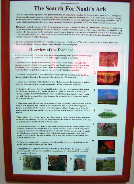
The archaeological site of the Ark is named after Durupinar, the Turkish pilot who first photographed it on a mapping assignment from NATO. The site is located at 39° 50 min. N. latitude N. and 43° 45 min. E. longitude, 2 miles north of the Iranian border,10 miles southeast of Dogubayazit, and 18 miles south of Greater Mount Ararat. The elevation of the Durupinar site is approximately 6,300 feet above sea leveㅣ
<Noah’s Ark and the Visitors’ Center>
도우베야짓 터미널, 노아방주 터를 가기위한 터미널 (출처-http://blog.daum.net/wonsunbe)

Ron Wyatt and Mr. Sevket Ekinci (출처-http://wyattmuseum.com/noahsark.htm)
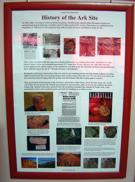
Plans were made for the official dedication of the site, which would include Ron as guest of honor as the "discoverer" of the fact that it was truly the remains of Noah's Ark.
노아방주 기념관
기념관 내부 , 노아방주 터를 처음 발견한 노인과 함께 (출처- http://blog.daum.net/wonsunbe)
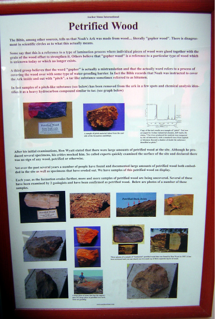
방주 나무
방주 터
방주 돌닺
방주 터
방주 터 발견의 역사
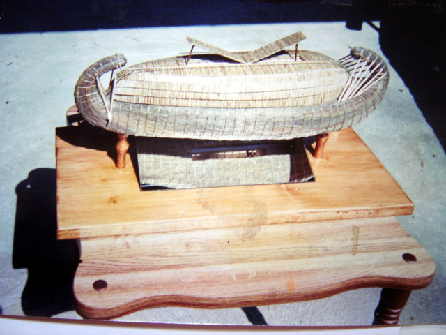
노아방주 모형
< Noah’s Ark>
The Crashdown Path of Noah's Ark (출처-http://www.panoramio.com/photo/39961696)
This is the alcove, in the center and rear, where the ark came to rest originally, higher on the mountain. In the distance straight ahead is the Iranian guard tower. To the left on the ridge is the Turkish guard tower. If you walk up here there is a good chance you will be arrested by the Turks, as has already happened (출처-http://www.arkdiscovery.com/noah's_ark.htm)
Using our zoom lens from the road in the valley, we can see the ark at left and the visitors' center roof at right. In the distance is the Iranian guard tower (출처-http://www.arkdiscovery.com/noah's_ark.htm)
'노아의 방주' 터키 아라라트山에서 발견 (2010.4)
중국과 터키의 전문가들로 구성된 복음주의 탐사대가 구약성경 ‘창세기’에 나오는 ‘노아의 방주’를 터키 아라라트산에서 찾아낸 것 같다고 주장했다. 2010.4.27일(현지시간) AFP통신 등 외신들에 따르면 탐사대는 터키 동부 아라라트산의 해발 고도 4000m 지점에서 거대한 목조 구조물을 발견했다. 목재 표본의 탄소 연대를 측정해본 결과 목재는 4800년 전의 것으로 확인됐다. 이는 노아의 방주가 띄워졌다는 시기와 비슷하다. 탐사대원 15명 가운데 한 사람인 홍콩의 다큐멘터리 제작자 양융샹(楊永祥)은 “이번에 발견한 구조물이 노아의 방주라고 100% 확신 못하지만 99.9%는 확신한다”고. 목재 구조물은 여러 칸으로 구분돼 있다. 몇몇 칸에는 나무 기둥까지 받쳐져 있다. 이는 동물 우리로 추정된다. 탐사대는 목재 구조물이 인간의 거주 시설이라고는 생각하지 않는다. 인근 지역 해발 고도 3500m 이상에서 지금까지 거주 시설이 발견된 적은 없기 때문이다. 현지 당국은 중앙정부에 유네스코 세계 유산 등재를 신청하도록 요구할 방침이다. 발굴 작업이 본격적으로 시작될 때까지 목재 구조물을 보호하기 위해서다. 창세기에 따르면 세상이 타락한 데 노한 여호와는 세상을 홍수로 쓸어버리리라 작정하고 노아에게 방주를 만들라고 명했다. 그리고 방주에 모든 동물을 한 쌍씩 태우도록 했다. 세상을 가득 채운 물이 서서히 빠지면서 방주는 어느 산에 안착하게 된다. 많은 사람이 그 산을 인근에서 가장 높은 아라라트산이라고 믿고 있다
Noah's Ark (출처-http://www.panoramio.com/photo/39961696
Noah's Ark (출처-http://wyattmuseum.com/noahsark.htm)
We can see how the earth has dropped around the sides of the ark (출처-http://www.arkdiscovery.com/noah's_ark.htm)
# 일간스포츠 1977. 4. 2.
“「노아 방주」를 탐색- 노아의 방주는 수세기 동안 여러번 발견됐었으며 1916년 낙하산으로 투하된 백러시아 군대 150명은 실제로 방주 안에 들어가 보고 크기를 재었으며 사진도 찍었다고 말했다. 이들은 방주 안에서 쇠창살이 달린 짐승 우리와 짐승의 털 그 밖에 유품들을 발견하고 돌아와 황제(니콜라이 Ⅱ세)에게 자세히 보고했으나 곧 볼세비키 혁명이 일어나 이같은 종교적인 사실은 묻혀 버리고 말았다는 것. 이 중 살아남은 4명의 러시아인들이 후에 미국과 캐나다에 와서 들려준 경험담을 듣고 ’74년 탐험을 감행한 2명의 미국인은 터어키의 아라랏산 중턱에서(약 5,000m) 방주로 믿어지는 배의 600m 부근까지 접근했으나 심한 구름과 안개 그리고 시간이 없었기 때문에 돌아올 수밖에 없었다. 그들은 『노아의 방주 재발견』, 『노아의 방주를 찾아서』 등의 책을 출판했다.”
# 전일신문 1970. 4. 11.
“다시 떠오르는 노아의 방주 행방. 과학자들 사진 분석이 발단 - 아라라트 산정 얼음 속에 있다. 터어키·소련·이란 접경 근처, 학자들 다퉈 현지 답사. 지구자원 기술위성이 지상 720km상공에서 촬영한 필름에 아라라트 산 위의 한 구조물이 찍혔다. 사진에 나타난 실제의 윤곽은 성서에 나타난 방주의 칫수(길이 137m, 너비 45m, 높이 22m)보다 다소 크지만 그늘진 그의 내부는 칫수가 꼭 맞아 떨어질 수 있다고 몽고메리 박사가 말했다. 몽고메리 박사는 3차례 탐색을 시도했으며 『노아의 방주 탐색』이라는 책도 저술했다.”
# 조선일보 1974. 7. 6.
“표고 5,165m의 아라랏산은 구약성서 창세기에 기록된 그 유명한 노아의 방주가 멎었던 산. 이곳을 지나간 고금의 모든 여행가들은 이 노아의 방주의 산에 대해 언급해 놓고 있으며, 이를 확인하기 위한 탐험대가 1829년에서 1955년에 이르기까지 수십 차례 파견돼 오기도 했었다. 1883년 터키 군부에서 파견된 탐험대가 정상 부근의 빙하에서 거대한 골조의 목조물을 발견하였고, 1916년에는 러시아 군부에서 150명에 이르는 대탐험대를 파견 거대한 배의 유해를 발견했었다. 프랑스의 탐험가 페르난드 나바라는 18년 동안 노아의 홍수와 방주에 관한 면밀한 문헌 조사 끝에 그 진실성을 인정하고 1952년부터 3년간에 걸쳐 현지 탐사를 감행했다. 그는 4,100m 지점에서 거대한 배의 현(舷) 부분을 발굴, 1m 50㎝로 잘라서 짊어지고 돌아왔다. 전문가에 감정시켜 보았더니 구약성서시대의 목재임이 틀림 없다는 고증을 얻은 것이었다.”
# 중앙일보 1984. 8. 27.
“터어키서 노아 방주 발견. 미 탐험대 5,000m 산에서 - 미 제임스 어윈이 터키 동부 해발 5,165m의 아라라트산에서 구약성경에 나오는 노아의 방주를 발견했다고 주장. 탐사대장 스틴핀스 씨는 앙카라의 미 문화원에 전화를 걸어 어윈이 지난 22일 이 산을 등반한 뒤 방주를 발견했다고 전하고 공식발표를 하기 위해 문화원 측에 기자회견을 해 두도록 요청했다고 발표했다
View from rear, with pointed bow in distance (출처-http://www.arkdiscovery.com/noah's_ark.htm)
Ark with features labeled (출처-http://www.arkdiscovery.com/noah's_ark.htm)
The symmetrical shape of the ark can been seen from the rear, with a center mound that is the deck area that has collapsed, and the port and starboards side to the left and right.
A boy can be seen at the rear(출처-http://www.arkdiscovery.com/noah's_ark.htm)
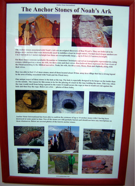
Drogue anchors (출처-http://wyattmuseum.com/noahsark.htm)
Drogue anchors are designed to drag in the water, stabilize a ship and keep it perpendicular to the oncoming waves; not to prevent it from moving. This type of drogue anchors, which have broken away, are sometimes found on the floor of the Mediterranean and other seas as they were common to ancient ships. Ron observed crosses on the anchor stones. Some of the anchors seem to have had eight original crosses carved on them. These crosses are Byzantine style which indicates that someone after 300 A.D. recognized these anchorstones as having a connection with Noah's Ark and carved the crosses at that time.
Ark visitors checking out the port side dynamited hole (출처-http://www.arkdiscovery.com/tour-around.htm)
Close-up photo of the hole (출처-http://www.arkdiscovery.com/tour-around.htm)
"Horizontal Deck Support Timbers" (출처-http://wyattmuseum.com/noahsark.htm)
Results of the "Mini-Excavation"(As viewed in the morning sun light) (출처-http://wyattmuseum.com/noahsark.htm
Continuing down the starboard or right side near the rear. The limestone outcropping is out of the photo to our right. Notice the vertical rib timbers in a regular man-made sequence (출처-http://www.arkdiscovery.com/tour-around.htm)
The mid-port, or left area of the ark features the hole that was blown out by the 1960 expedition that was published in Life magazine. It is in the left, upper portion (출처-http://www.arkdiscovery.com/tour-around.htm)
The left rear of the ark features vertical ribs, with one complete, tall rib in left portion of this photo
(출처-http://www.arkdiscovery.com/tour-around.htm)

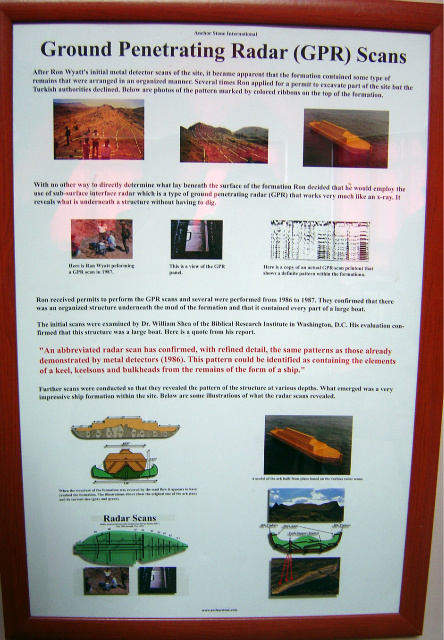
Diagram of the ark based upon radar scans (출처-http://www.arkdiscovery.com/noah's_ark.htm)
노아방주 터 위성사진
미국 일간 USA 투데이는 9일자 온라인 기사에서 '노아의 방주 미스터리'가 또 다시 화제가 되고 있다고 보도했다. 일부 연구자들이 '노아의 방주'로 주장해 온 물체(혹은 지형)를 담은 선명한 위성 사진이 공개되었기 때문. 포르세 테일러 등 노아의 방주 연구자들은 성서에 묘사된 40일 대홍수가 끝난 뒤 방주가 터키 아라라트 산에 안착했을 가능성이 높다고 주장해왔다. 그 증거로서 4663미터 높이의 산허리에 있는 비정상적인 지형의항공 및 위성 촬영 사진이 제시되어 왔다. 그림자에 불과하다거나 자연 지형이라는 반박도 있었지만, 인간이 만든 구조물이라는 가설도 있어 왔다. 그런데 최근 문제의 지역을 촬영한 선명한 위성 사진이 공개되면서 다시 논란이 가열되기 시작했다. 디지털글로브(DigitalGlobe)사의 위성이 2003년에 촬영한 사진이 일반에 공개된 것이다. 노아의 방주가 실존한다고 믿고 10여 년 동안 연구를 진행해온 포르세 테일러는, 이번에 공개된 사진이 노아의 방주 미스터리를 푸는 데 큰 기여를 할 것이라고 보고 있다. 그는 문제의 물체가 노아의 방주일 가능성이 높다고 주장한다. 길이와 너비가 6:1 비율로 노아의 방주에 대한 성서 기록과 일치한다는 것이 그가 제시한 논거 중 하나. 아라라트 산허리의 물체 길이는 309미터이다. 언론은 상업 위성 사진은 물론 군사 위성 사진들도 속속 공개되고 있기 때문에 머지않아 노아의 방주 미스터리가 풀리게 될 것으로 낙관하는 전망이 나오고 있다고 전했다. (사진 : 디지털글로브사의 상업위성 퀵버드가 2003년 촬영한 사진 ⓒDigitalGlobe 출처 www.space.com)
The image on this Web Page is used with the permission of Wyatt Archaeological Research
(출처-http://www.arkonararat.yolasite.com/)
Associated Press (출처-http://wyattmuseum.com/noahsark.htm)
Hurriyet - Turkish Newspaper (출처-http://wyattmuseum.com/noahsark.htm)
The plans were made public for a visitors' center to be erected on the spot. The governor spoke the dedication in Turkish and then he lifted the first shovel full of dirt - the groundbreaking of the new visitors' center. Ron, as guest of honor, lifted the second shovel full of dirt and then other dignitaries participated in the ceremony.
The image on this Web Page is used with the permission of Wyatt Archaeological Research
(출처-http://www.arkonararat.yolasite.com/)
Research on the Width of the Ark (출처-http://www.arkonararat.yolasite.com/)
Sub-surface radar is a device built by Geophysical Survey Systems Incorporated (GSSI) that can chart the presence of objects below the surface (출처-http://wyattmuseum.com/noahsark.htm)
Rib Timbers (출처-http://wyattmuseum.com/noahsark.htm)
Rivets" in matrix material (출처-http://wyattmuseum.com/noahsark.htm)
"Rivet" (출처-http://wyattmuseum.com/noahsark.htm)
Ron had previously photographed what looked like groupings of metal fittings on the sides of "Noah's Ark", but he could not disturb them by cleaning them off.
Possible Oxide CompositionLocation 2 "Rivet" (출처-http://wyattmuseum.com/noahsark.htm)
Quantitative Elemental Analysis of "Rivet"Location 1 = Material surrounding "Rivet"Location 2 = "Rivet
(출처-http://wyattmuseum.com/noahsark.htm)
Broken stone with eight crosses, in the Village of Eight, named for the eight survivors of the Flood. The largest cross represents Noah, to the left is a cross for Mrs. Noah, then three smaller crosses for the sons of Noah, then the three smallest for the wives of the sons (출처-http://www.arkdiscovery.com/noah's_ark.htm)
Deck Timbe (출처-http://wyattmuseum.com/noahsark.htm)
The excavation of the object was documented by way of film and aired throughout Turkey by way of TRT (Turkish Radio and Television).The Governor presented Ron with the specimen for the purpose of analysis in the United States.
Large anchor stone with Mt. Ararat in distance, and Dr. Robert Michelson of Georgia Tech inspecting the stone. The stones were cut off in this area, then the ark floated more freely to its final landing place about 12 miles away. Dr. Michelson gives a three hour
presentation on the Noah's ark site (출처-http://www.arkdiscovery.com/noah's_ark.htm)
Large anchor stone (출처-http://www.arkonararat.yolasite.com/)
Ron Wyatt found large stones, identical in design to smaller drogue anchor stones. Drogue anchors are designed to drag in the water, stabilize a ship and keep it perpendicular to the oncoming waves; not to prevent it from moving
The top was broken off by vandals, to the right, but was laying nearby.
Crosses are carved on this one also. (출처-http://www.arkdiscovery.com/noah's_ark.htm)
The top was broken off by vandals, to the right, but was laying nearby. Crosses are carved on this one also.
(출처-http://www.arkdiscovery.com/noah's_ark.htm)
노아의 방주 [Noah's ark]
모든 사람들이 타락한 생활에 빠져 있어 하느님이 홍수로 심판하려 할 때 홀로 바르게 살던 노아는 하느님의 특별한 계시로 홍수가 올 것을 미리 알게 된다. 그는 120년에 걸쳐 방주(길이 90.9m, 너비 15.15m, 높이 9.09m, 상 ·중 ·하 3층으로 된 배)를 만들어 8명의 가족과, 한 쌍씩의 여러 동물을 데리고 이 방주에 탄다. 대홍수를 만나 모든 생물이 전멸하고 말았지만, 이 방주에 탔던 노아의 가족과 동물들은 살아 남았다고 한다. 노아라는 말은 헤브라이어로 ‘휴식’이라는 뜻인데, 노아는 신앙의 모범, 방주는 신자의 단체인 교회, 대홍수는 하느님의 심판을 상징하며, 원시교회 이래 그리스도교 예술의 소재로 많이 다루어지고 있다


